Best Beaches at Pictured Rocks National Lakeshore (With ADA + Dog Info)
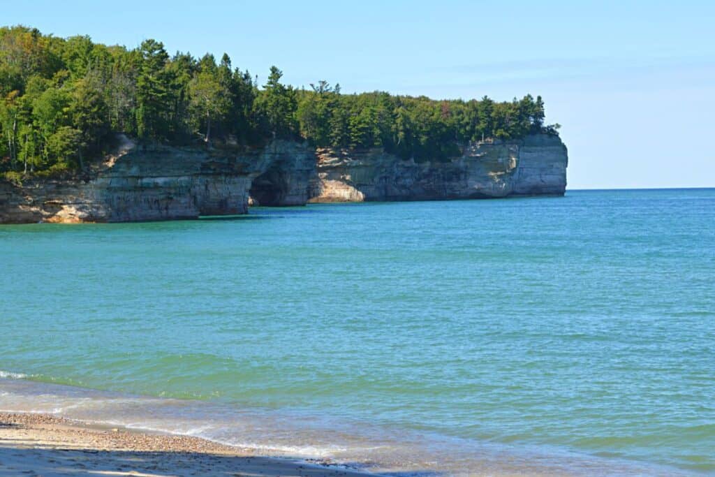
Pictured Rocks National Lakeshore has nine distinct beaches stretched across 42 miles of Lake Superior shoreline in Michigan’s Upper Peninsula — and no two are the same. Sand Point sits sheltered in Munising Bay with pink garnet sand and the warmest water in the park. Chapel Beach requires a 2-mile hike through old-growth forest and delivers a view of the open lake beneath towering sandstone cliffs.
Last Updated: March 2026
Between them, you’ll find rocky shores, dunes, river mouths, and backcountry stretches that most visitors never reach. I’ve been to all of them — here’s an honest breakdown of each, including exact dog policies, ADA access, swimming conditions, and what the NPS website doesn’t spell out clearly enough.
📌 Pictured Rocks Beaches: In a Nutshell
- No lifeguards anywhere in the park or surrounding communities. Lake Superior is cold (rarely above low 60s°F on open-lake beaches; Sand Point can reach low 70s°F in late summer), with rip currents and fast-changing conditions. Swim with caution.
- Best for swimming: Sand Point Beach — sheltered, warmest water, wheelchair mat to water’s edge, leashed dogs welcome
- Best for seclusion: Chapel Beach and Mosquito Beach (2+ mile hike required; no dogs permitted)
- Best for rock hunting: Grand Marais Public Beach / Agate Beach — outside the park boundary, collecting is legal here
- ADA-accessible beaches: Sand Point (wheelchair mat to water), Miners Beach (accessible boardwalk to overlook platform), Lake Superior Overlook (accessible platform; 38 steps to beach)
- Dog-friendly beaches (6-ft leash required): Sand Point ✅ · Miners Beach ✅ · Twelvemile Beach ✅ · Lake Superior Overlook ✅ · Hurricane River ✅ · Sable Falls ✅. Dogs NOT permitted at Chapel Beach, Mosquito Beach, or any backcountry beach.
- Entrance fee: $25/vehicle · $20/motorcycle · $15/person on foot or bike. Park is cashless — no cash accepted. America the Beautiful Pass accepted. 2026 fee details at nps.gov.
- Rock collecting is illegal inside the national lakeshore — take only photographs.
📍 Location: Pictured Rocks National Lakeshore · Alger County, Upper Peninsula, Michigan · Munising to Grand Marais along Lake Superior · Drives: ~4.5 hrs from Detroit · ~5 hrs from Chicago · ~2.5 hrs from Green Bay · Phone: 906-387-3700 · Website: nps.gov/piro
Interactive Map of Pictured Rocks Beaches

Beaches Inside Pictured Rocks National Lakeshore
All nine beaches inside the park boundary are federally protected. No rocks, shells, or natural materials may be collected — the reason these shores remain genuinely pristine after millions of visitors. The park charges an entrance fee and is cashless (credit/debit only — no cash accepted at any entrance point). America the Beautiful passes are accepted. Current fees at nps.gov.
2026 Free Entrance Days: May 25 (Memorial Day) · July 3–5 (Independence Day weekend) · August 25 (NPS 110th Birthday) · September 17 (Constitution Day) · November 11 (Veterans Day). Mark your calendar if you’re planning around these dates.
Sand Point Beach
📍 End of Sand Point Rd., Munising, MI 49862 · 🐾 Leashed dogs welcome · ♿ Wheelchair mat to water’s edge; accessible picnic table on sand; accessible restrooms · 💰 Park entrance fee required · 🌐 nps.gov/piro
Sand Point Beach is the most accessible, most family-friendly, and best swimming beach in the park — and it’s the first place I take anyone visiting Pictured Rocks for the first time. The beach sits inside Munising Bay, sheltered from open Lake Superior by Grand Island directly across the water. That shelter does two things: it cuts the swells dramatically and keeps the water warmer than anywhere else in the park. In late summer, Sand Point can reach the low 70s°F — remarkable for Lake Superior, where open-lake beaches rarely get above the low 60s.

The pink tint in the sand comes from crushed garnet sandstone — one of those details you notice once and can’t unsee. A wheelchair-accessible mat extends from the parking lot all the way to the water’s edge (seasonal), and there’s one wheelchair-accessible picnic table right on the sand. The Sand Point Marsh Trail — a half-mile ADA-accessible boardwalk — begins at the parking area and is one of the best short accessible walks in the entire park. This is also the only beach in the park with a fire ring available for use (first-come, first-served).
Miners Beach
📍 Miners Beach Rd., off H-58, Munising, MI 49862 (approx. 6 miles east of town) · 🐾 Leashed dogs welcome at beach (not on the trail from Miners Castle — drive your dog to the beach parking area directly) · ♿ Accessible boardwalk to scenic overlook platform; stairs to beach · 💰 Park entrance fee required · 🌐 nps.gov/piro
Miners Beach stretches nearly a mile of sand and dark-speckled rock just east of the Miners River — with Bridalveil Falls and the high sandstone cliffs visible in the distance to the east on a clear day. It pairs perfectly with a stop at Miners Castle, the park’s most visited rock formation, a short drive away. Hike the Castle viewpoints first (the two upper platforms are ADA-accessible and dogs are welcome on the paved pathways), then drive back down to the beach for swimming and a picnic.

From the main parking area, an accessible boardwalk leads through a pine forest to an elevated overlook platform with views of the beach and lake — a worthwhile stop even if you’re not heading to the sand. Stairs lead from the platform down to the beach itself. Note: dogs are not allowed on the trail between Miners Castle and the beach, but you can drive directly to the beach parking area with your dog and enjoy the full stretch of shoreline together.
Twelvemile Beach
📍 Twelvemile Beach Campground, H-58, approximately 34 miles east of Munising · 🐾 Leashed dogs welcome · ♿ Not accessible to beach level — long flight of stairs · 💰 Park entrance fee required · 🌐 nps.gov/piro
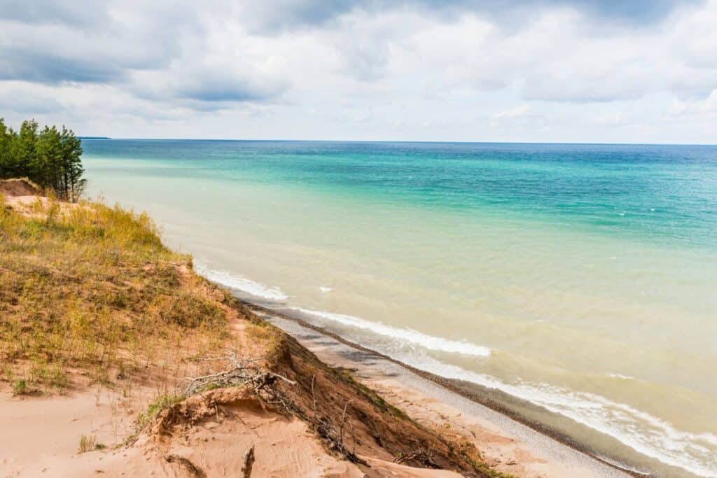
As the name suggests, there’s a 12-mile-long stretch of pristine sand extending east of the cliffs through the center of the lakeshore. This is open Lake Superior with no sheltering bay — beautiful, dramatic, and colder than Sand Point. Most visitors access it from the Twelvemile Beach Campground day-use area, where the beach sits at the bottom of a long flight of stairs from the bluff. Leashed dogs are welcome on the beach. The two-mile White Birch Nature Trail also begins here, and the North Country Scenic Trail runs through the campground.
Hurricane River Beach
📍 Hurricane River Campground day-use area, H-58, approximately 12 miles west of Grand Marais · 🐾 Leashed dogs welcome (also permitted at Au Sable Light Station grounds, not inside buildings) · ♿ Short flight of stairs to beach · 💰 Park entrance fee required · 🌐 nps.gov/piro
Hurricane River Beach forms at the mouth of the Hurricane River where it empties into Lake Superior — a dynamic shoreline that changes shape every season. Lake Superior doesn’t have tides but does experience seiche-driven water level changes, and when levels drop, scattered boulders emerge and you can walk the beach about 1.5 miles east toward the Au Sable Light Station. That walk is one of the more quietly spectacular things you can do in the park — shipwreck remains are visible along the shore at low water. A flat 1.8-mile round-trip trail from the campground also leads to the lighthouse.
Lake Superior Overlook Beach
📍 H-58, just east of Twelvemile Beach Campground · 🐾 Leashed dogs welcome · ♿ Accessible overlook platform; 38 steps to beach · 💰 Park entrance fee required · 🌐 nps.gov/piro
A parking area with a paved, wheelchair-accessible overlook platform sits above a rocky Lake Superior beach reached by 38 steps. Sullivan’s Creek empties into the lake just west of the parking area. Good for a quick stop, a cold swim, or a short walk along the shoreline. The overlook itself is genuinely worth the pull-off — the view across open Lake Superior from this section of the coast is less photographed than Miners Castle but no less impressive.
Chapel Beach
📍 Chapel Road trailhead, approximately 15 miles northeast of Munising · 🐾 Dogs NOT permitted · ♿ Not accessible — 2-mile natural surface trail required · 💰 Park entrance fee required · 🌐 nps.gov/piro
Chapel Beach is the most rewarding beach in the park — and you have to earn it. The hike in is roughly 2 miles one-way from the Chapel Road trailhead along the Chapel Loop, passing through maple forest with patches of understory wildflowers before breaking out onto soft sand with an endless open horizon over Lake Superior. What you get at the end is the park at its most elemental: no road access, no facilities, just the lake, the cliffs to the east, and the sound of water. Chapel Rock — the famous lone-white-pine formation — stands at the east end of the beach, and the 60-foot Chapel Falls is a short detour off the trail. Early fall, when the maple canopy above the trail turns deep red and the cliffs above the beach go gold, is the best time. No dogs permitted. Not ADA accessible.
Mosquito Beach
📍 Chapel Road trailhead, approximately 15 miles northeast of Munising · 🐾 Dogs NOT permitted · ♿ Not accessible — approximately 4-mile round-trip trail on natural surface · 💰 Park entrance fee required · 🌐 nps.gov/piro
Don’t let the name discourage you. Mosquito Beach sits at the end of a 4-mile round-trip hike from the Chapel Road trailhead, following the Mosquito River through lowland forest of conifers and hemlocks before opening onto a mix of sand and mid-size boulders at the Lake Superior shoreline. The boulders scattered across the beach and into the shallows give it a completely different feel from any other beach in the park — less polished, more ancient. Accessible for novice hikers who are comfortable with the distance. No dogs permitted. Not ADA accessible.
Sable Falls Beach
📍 Sable Falls parking area, Grand Marais, MI 49839 (eastern end of the park) · 🐾 Leashed dogs welcome on trail and beach · ♿ Not accessible to beach level — 168 steps total · 💰 Park entrance fee required · 🌐 nps.gov/piro
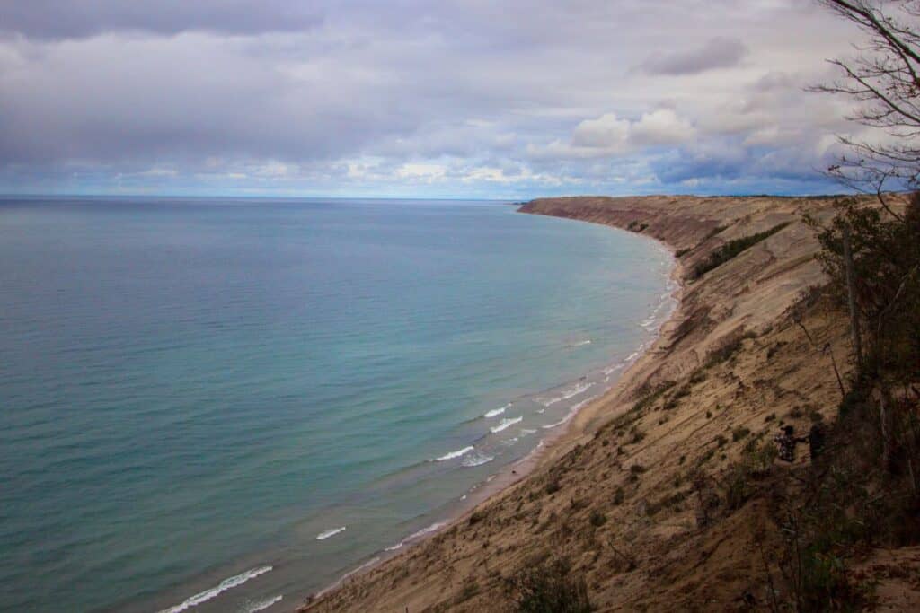
Sable Falls Beach sits at the base of a 75-foot waterfall at the eastern end of the park, framed by the Grand Sable Dunes rising more than 300 feet above the lake. The trail from the parking lot is only about a quarter-mile, but descends 168 steps to reach the falls and beach — one of the more visually dramatic beach arrivals in the park. The beach itself is rocky and sandy, with the dunes looming above and open Lake Superior stretching east. Leashed dogs are welcome — one of the better dog-friendly experiences in the park given the short trail distance. The parking lot has seasonal flush restrooms and picnic tables.
Beaches Outside the Park — Where Rock Collecting Is Legal
Just outside the park boundaries, collecting rocks and agates from the shore is legal. These beaches are excellent companions to a Pictured Rocks trip — same Lake Superior scenery, more relaxed rules, and often significantly fewer crowds.
AuTrain Beach
📍 M-28, AuTrain, MI 49806 (approximately 15 miles west of Munising) · 🐾 Dogs welcome · ♿ Roadside access, generally flat · 💰 No park entrance fee — outside national lakeshore
AuTrain Beach sits west of Munising along M-28, well outside the national lakeshore boundary. It’s a long, sandy, roadside Lake Superior beach with a fraction of the park’s crowds. The Au Train River flows from Au Train Lake into Lake Superior here — the river water warms faster than the open lake, making the area around the river mouth a popular summer swimming spot. No entrance fee, no restrictions on rock collecting, and easy pull-off access make this one of the most underrated stops on a Pictured Rocks trip.
Grand Marais Public Beach (Agate Beach)
📍 Lake Ave., Grand Marais, MI 49839 (eastern end of park area) · 🐾 Dogs welcome · ♿ Generally accessible from street level · 💰 Free — outside national lakeshore · 🌐 grandmarais-michigan.com
At the eastern end of the Pictured Rocks area, the village of Grand Marais sits just outside the protected park boundary — which means rock and agate collecting is legal on the beach here. Known locally as Agate Beach, it’s more cobble than sand, but the Lake Superior agates visible after a good wave are worth the crouch. The town of Grand Marais is worth an hour of your time on its own — a small harbor, a few restaurants, and a genuinely unhurried Upper Peninsula atmosphere that feels completely removed from the park crowds in Munising.
Frequently Asked Questions About Pictured Rocks Beaches
Which Pictured Rocks beach is best for swimming?
Sand Point Beach is the best swimming beach in the park. It’s sheltered inside Munising Bay by Grand Island, which cuts the swells and keeps the water warmer — reaching the low 70s°F in late summer, unusual for Lake Superior. It’s also the only beach with a wheelchair-accessible mat extending to the water’s edge, and leashed dogs are welcome. Open-lake beaches like Twelvemile Beach and Hurricane River rarely get above the low 60s°F even in August. There are no lifeguards at any beach in or around the park.
Which Pictured Rocks beaches allow dogs?
Leashed dogs (6-foot maximum) are allowed at Sand Point Beach, Miners Beach, Twelvemile Beach, Lake Superior Overlook, Hurricane River Beach, and Sable Falls Beach. Dogs are not permitted at Chapel Beach, Mosquito Beach, or any backcountry beach in the Beaver Basin Wilderness. Always verify current rules before your visit at nps.gov/piro/planyourvisit/pets.htm — dog access policies have expanded in recent years and some older online guides are outdated.
Can you collect rocks at Pictured Rocks beaches?
No — rock collecting is illegal inside Pictured Rocks National Lakeshore. For legal agate and rock hunting on Lake Superior, go to Grand Marais Public Beach (Agate Beach) just east of the park boundary, or AuTrain Beach approximately 15 miles west of Munising. Both are outside the protected lakeshore and collecting is permitted.
What is the water temperature at Pictured Rocks beaches?
Lake Superior is cold year-round. At open-lake beaches like Twelvemile Beach and Hurricane River, water temperatures rarely exceed the low 60s°F even in August. Sand Point Beach — sheltered inside Munising Bay — is the exception, sometimes reaching the low 70s°F in late summer. Hypothermia is a real risk in Lake Superior even in summer. Never swim alone, and don’t underestimate the cold even on warm days.
Is there a fee to access Pictured Rocks beaches?
Yes. All beaches inside the national lakeshore require an entrance pass: $25 per private vehicle, $20 per motorcycle, $15 per person on foot or bike. The park is cashless — credit and debit cards only, no cash accepted at any entrance point. America the Beautiful passes are accepted. There are also six free entrance days in 2026, including Memorial Day (May 25), Independence Day weekend (July 3–5), and Veterans Day (November 11). Full fee details at nps.gov. Beaches outside the park boundary — AuTrain Beach and Grand Marais Public Beach — are free.
What is the best time to visit Pictured Rocks beaches?
Late July through mid-August offers the warmest water and peak conditions for swimming. The park is busiest June through August — arrive early at Sand Point and Miners Beach on summer weekends. Late September through mid-October is the best time to hike to Chapel Beach and Mosquito Beach: cooler temperatures keep bugs down, the maple canopy turns red and gold, and the crowds thin substantially. The park is open year-round; winter brings blue ice formations on the lakeshore cliffs, typically visible January through early March.
Keep Exploring Pictured Rocks
→ Pictured Rocks National Lakeshore: The Complete Visitor’s Guide
→ Pictured Rocks Kayaking: 5 Must-See Spots
→ Best Pictured Rocks Campgrounds
- About Jill
- Recent Michigan Travel Tips

Jill Halpin is a Michigan travel expert and founder of MyMichiganBeach.com, one of the state’s leading travel resources. Based in Michigan, Jill is known for her in-depth knowledge of Michigan destinations, from beach towns and Great Lakes getaways to hidden inland gems. She appears regularly as a TV travel contributor on WDIV Detroit, Fox17 West Michigan, Fox2 Detroit, and other Midwest media, and her travel expertise has been featured in The Detroit News and across major digital outlets.
Jill is a member of top Michigan tourism organizations and is dedicated to helping travelers discover the best things to do, see, and experience throughout the state year-round. See more at MyMichiganBeach.com/media.