
Explore Upper Peninsula Michigan: 14 Places Worth the Drive, Mapped
Last Updated: August 2026
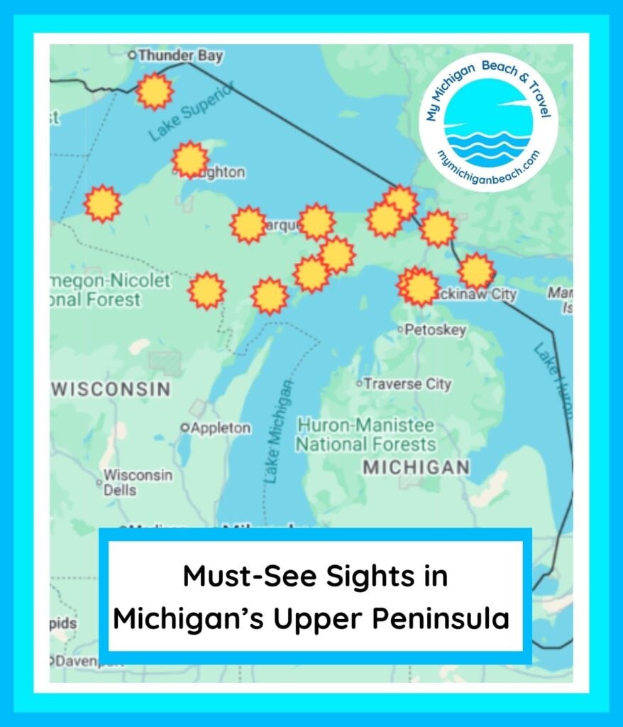
These are the fourteen places in Michigan’s Upper Peninsula I’d send someone to first — waterfalls, islands, harbor towns, and one spring that never freezes. The map below shows roughly where each one sits, which matters more than you’d think: the U.P. runs about 320 miles from Ironwood to the Soo, and the distance between two stops that look close on a page is often most of a day.

This is written for anyone planning a first or second trip to the U.P. and trying to work out a realistic route rather than a wish list. Every stop below includes what it costs to get in, whether dogs are welcome, and what the access is actually like — the details that decide whether a place works for your group before you drive four hours to find out.
At a Glance: Planning a U.P. Trip
- How big it really is: About 320 miles end to end. Driving Ironwood to Sault Ste. Marie is a full day, not a morning.
- Three Great Lakes: Superior along the north, Michigan along the south and west, Huron at the eastern tip. Most U.P. trips only touch one or two.
- What you’ll need at state parks: A Michigan Recreation Passport. As of 2026, $15 a year on Michigan plates at plate renewal, or $20 if you buy it at the park. Out-of-state plates pay $12 daily or $42 annually.
- Where dogs can’t go: Isle Royale National Park bans pets entirely. Nearly everywhere else on this list allows leashed dogs.
- Easiest entry point: St. Ignace, right over the Mackinac Bridge. Tahquamenon, Whitefish Point, and the Soo are all within about 90 minutes.
- Hardest to reach: Isle Royale. It’s a ferry or seaplane trip with a fixed season, not a spontaneous stop.
- Best window for a first visit: Late June through early October. Many concessions, ferries, and park services run seasonally.
How to Group These Stops Into an Actual Trip
The U.P. splits into three practical trip regions, and picking one beats trying to see everything. The eastern U.P. is everything within an easy drive of the Mackinac Bridge — St. Ignace, Tahquamenon Falls, Whitefish Point, Sault Ste. Marie, Drummond Island. It’s the most accessible half-day from downstate.
The central U.P. covers Munising and Pictured Rocks, Marquette, Seney, and Kitch-iti-kipi. This is where most people spend their first real U.P. week. The western U.P. — the Keweenaw, Copper Harbor, the Porcupine Mountains, Isle Royale — is the remotest and the most rewarding, and it’s genuinely far. Copper Harbor is about eight hours from Detroit.
Here’s what I’d do with a first trip: pick two adjacent regions, not three. A week split between the central and eastern U.P. gives you Pictured Rocks, Tahquamenon, and Whitefish Point without a driving day in the middle. Save the Keweenaw for its own trip — it deserves one.
Quick Picks by Interest
- First-timers: Pictured Rocks and Tahquamenon Falls. They’re the two people picture when they picture the U.P., and both deliver.
- Families with young kids: Kitch-iti-kipi. The raft ride is short, the walk from the lot is under a minute, and nobody has to hike.
- Accessibility needs: Kitch-iti-kipi’s paved path and observation raft are both accessible, and Seney’s Marshland Wildlife Drive is seen entirely from your car.
- Traveling with a dog: Everywhere on this list except Isle Royale, where pets are prohibited.
- Photographers: Brockway Mountain in the Keweenaw and Black Rocks at Presque Isle Park in Marquette.
- Wanting genuine solitude: Isle Royale or Drummond Island. Both take real effort to reach, which is the point.
Isle Royale National Park
Isle Royale is the largest island in Lake Superior and the least-visited national park in the contiguous United States — and both facts come down to the same thing: you can’t drive there. It sits 45 miles long and 9 miles wide in the northwest corner of Superior, closer to Ontario than to Michigan, with no roads, no cars, and no permanent residents.
The Isle Royale Queen IV runs from Copper Harbor to Rock Harbor, departing at 8:00 a.m. and returning from the island at 2:45 p.m. The operator puts the crossing at roughly three hours and forty-five minutes each way. Do that math before you book a day trip: you’ll have about three hours on the island, of which maybe two are usable for hiking. It’s a long day for a short visit.
The park runs on a season — it closes entirely in winter, and the Queen IV typically sails from early May through the end of September. A per-person daily entrance fee applies and is best paid before you travel. Wolves and moose are the headline wildlife, and the island’s predator-prey study is the longest-running of its kind anywhere.
Pro tip: Pets are prohibited on Isle Royale, with no exception for leashed dogs left aboard a private boat. If you’re traveling with a dog, this is the one stop on the list you’ll have to skip.
If you want the full breakdown of ferries, camping, and how many days you actually need, I’ve written a complete guide to visiting Isle Royale.

Porcupine Mountains Wilderness State Park
The Porkies are the largest state park in Michigan and hold one of the biggest tracts of old-growth northern hardwood forest left anywhere east of the Mississippi. That’s the reason to come: the forest here was never logged, and it looks like it.
The Lake of the Clouds overlook is the photograph everyone knows, and it’s the rare famous viewpoint that’s genuinely easy to reach. Beyond that, the park holds more than 90 miles of trail, several waterfalls on the Presque Isle River, and backcountry cabins you reserve months ahead.
Entry requires a Recreation Passport. Leashed dogs are welcome on the trails. Plan on the western U.P. weather being its own thing — this corner of the state gets Lake Superior snow well into spring.
More on the trails and the overlook in my guide to the Porcupine Mountains.

Iron Mountain in Dickinson County
Iron Mountain sits in Dickinson County on the Wisconsin border, and it’s the U.P. town most people drive through rather than to. It’s worth a stop mainly for what’s just outside it.
Piers Gorge on the Menominee River is the standout — a stretch of whitewater with a short trail along it, about fifteen minutes south of town near Norway. Fumee Falls is a roadside stop off US-2 with a viewing platform close to the lot, which makes it one of the easier waterfalls in the U.P. to actually see. The Cornish Pumping Engine and Mining Museum holds the largest steam-driven pumping engine built in the United States.
The iron mines named the town and drove its growth through the late 1800s and early 1900s. If you’re routing through the western U.P. from Wisconsin, this is a reasonable place to break the drive.
Escanaba on Lake Michigan
Escanaba sits in Delta County on Little Bay de Noc, and it’s the largest city on the U.P.’s Lake Michigan shore. Ludington Park is the reason to stop — a waterfront park with a swimming beach, walking paths, a marina, and the Sand Point Lighthouse right inside it.
Little Bay de Noc is known statewide for walleye fishing, and the protected bay water warms earlier than Lake Superior does, which makes this a more realistic swimming stop than anywhere on the north shore. Downtown Escanaba has kept a working main street rather than a tourist one.
Why this matters for your route: Escanaba is on US-2, which is the southern road across the U.P. If you’re coming up from Chicago or western Michigan rather than over the bridge, this is your natural first night. More in my guide to things to do in Escanaba.

Kitch-iti-kipi, the Big Spring
Kitch-iti-kipi is Michigan’s largest natural freshwater spring, and it’s in Palms Book State Park at the northern end of M-149, about 11 miles north of US-2 near Manistique in Schoolcraft County. It’s the highest reward-to-effort ratio of anything on this list.
The spring runs 200 feet across and 40 feet deep. You cross it on a self-propelled observation raft with a viewing window in the floor — someone in your group turns a crank, and the whole trip takes fifteen or twenty minutes. There’s no separate charge for the raft.
The raft operates from 8 a.m. to dusk. The parking lot is a few steps from the water, the path is paved, and both the path and the raft are accessible. Leashed dogs are welcome on both. Swimming isn’t permitted.
Because the water is spring-fed at a constant temperature, it never freezes — which makes this one of the few U.P. stops that’s arguably better in winter, when everything around it has locked up and the spring hasn’t.

The Keweenaw Peninsula
The Keweenaw Peninsula reaches further into Lake Superior than anywhere else in Michigan, and it’s the part of the U.P. that feels least like the rest of the state. Copper built it, and the copper is gone, which is why the towns look the way they do.
The Quincy Mine above Hancock runs surface tours and an underground tram into the workings — worth it for the scale of the hoist house alone. Keweenaw National Historical Park isn’t a single site but a collection of them, anchored by the Calumet Historic District, where a boomtown of 30,000 shrank to a village and left the architecture standing.
For water and views, McLain State Park sits on the Superior shore near Hancock, and Brockway Mountain Drive above Copper Harbor climbs to one of the best vantage points in Michigan. Copper Harbor is also the departure point for the Isle Royale ferry, which makes it a logical base if you’re combining the two.

Marquette
Marquette is the largest city in the U.P. and the one place up here with a real downtown, a university, and enough restaurants that you’re choosing rather than settling. If you want one base for a central U.P. trip, this is it.
Presque Isle Park is a 323-acre peninsula at the north end of town with a loop road, a swimming area, and Black Rocks — the basalt cliffs people jump from into Lake Superior. Sugarloaf Mountain is a short, steep climb north of the city with stairs most of the way and a view over the whole bay at the top.
The Marquette Maritime Museum and the Marquette Harbor Lighthouse sit together on the water, and Northern Michigan University keeps the town feeling younger than its size suggests. Full detail in my Marquette travel guide.

Pictured Rocks National Lakeshore
Pictured Rocks covers 42 miles of Lake Superior shoreline between Munising and Grand Marais, and the sandstone cliffs are the reason most people make the drive.
Here’s the thing most first-timers get wrong: you can’t see the cliffs from land. The famous formations — Miners Castle is the exception, reachable by road — are visible from the water. That means a boat cruise out of Munising or a kayak trip. Plan and book that first, then build the rest of the day around it.
On land, the Lakeshore Trail runs the full length of the park, Chapel Rock and Chapel Falls make a solid half-day hike, and Miners Falls and Munising Falls are both short walks from parking. There’s no entrance station on the highway, but a park pass is required.

Seney National Wildlife Refuge
Seney covers more than 95,000 acres of wetland, forest, and grassland in Schoolcraft County, and it is the most underrated stop in the eastern half of the U.P. The Marshland Wildlife Drive is a seven-mile one-way gravel loop, with pull-offs and spotting scopes along the way.
That car-based format is why it belongs on more itineraries than it lands on. Nobody has to hike, everyone stays comfortable, and you’ll still see trumpeter swans, loons, sandhill cranes, and usually eagles. Early morning and the hour before dusk are when the wildlife is actually moving.
The Wildlife Drive is seasonal — it opens in spring and closes in the fall — so check the refuge’s own page before you route through. Admission is free.

Mackinac Island
Mackinac Island sits in the Straits of Mackinac in Mackinac County, which puts it in the U.P. administratively even though most people think of it as neither peninsula.
M-185 circles the island at 8.2 miles and is the only state highway in America with no motor vehicles, which makes it the single best thing to do here. Rent a bike at the dock, ride the loop, and you’ll pass Arch Rock, British Landing, and a shoreline most day visitors never leave Main Street to see.
Fort Mackinac sits above downtown with a view over the harbor, and the Grand Hotel’s porch is the longest of its kind anywhere. Ferries run from both St. Ignace and Mackinaw City. Leashed dogs are welcome on the ferries and on the island, which surprises people.

St. Ignace
St. Ignace is the first town you hit coming off the Mackinac Bridge, and it’s the practical gateway to the whole eastern U.P. It’s also the better ferry departure for Mackinac Island — a shorter crossing than from Mackinaw City, and the parking is usually easier.
The Museum of Ojibwa Culture sits on the site of a 17th-century Huron village and marks Father Marquette’s mission and burial place. The boardwalk runs along the Lake Huron shore through downtown, and the bridge view from the north side is the one you don’t get while driving it.
One correction worth knowing before you plan: Colonial Michilimackinac is in Mackinaw City, on the Lower Peninsula side of the bridge. Plenty of guides put it in St. Ignace. If it’s on your list, you’ll want to stop before you cross.

Drummond Island
Drummond Island sits at the far eastern end of the U.P. in Chippewa County, reached by a short car ferry from De Tour Village. It stays quiet in a way almost nowhere else on the Great Lakes manages in July.
The island is known for off-road trails — it has one of the largest ORV networks in the Midwest — and for the Marblehead area at the northeast corner, where limestone cliffs drop to the water and the fossil beds are genuinely good. Getting to Marblehead requires a high-clearance vehicle or a long walk.
Fair warning on the practicalities: services are limited, cell coverage is patchy, and the ferry runs on a schedule you should check rather than assume. That’s the tradeoff for having a Lake Huron shoreline mostly to yourself.

Sault Ste. Marie and the Soo Locks
Sault Ste. Marie is the oldest city in Michigan and the third-oldest continuously settled city in the United States. The Soo Locks are the reason to come, and they’re free to watch.
Every freighter carrying iron ore and grain out of Superior has to pass through these locks to get anywhere. The observation platform puts you close enough to thousand-foot ships that the scale stops being abstract. The visitor center posts a daily schedule of expected vessels, which is the thing to check before you plan your afternoon.
The locks close to navigation each winter for maintenance, roughly mid-January through late March, so a winter visit means an empty channel. The Tower of History gives a wider view of the river and the Canadian side.

Tahquamenon Falls State Park
Tahquamenon Falls is the second-largest waterfall east of the Mississippi by volume, and it’s the U.P. waterfall most people have already seen a photograph of.
There are two falls, four miles apart, and they’re different experiences. The Upper Falls is the big one — 200 feet across, roughly 50 feet high, with a paved path and a viewing platform close to the lot. The Lower Falls is a series of smaller cascades around an island, and you can rent a rowboat to reach it and wade in the shallows. Families usually prefer the Lower Falls; photographers usually prefer the Upper.
A Recreation Passport is required. Leashed dogs are welcome on the trails. The park is open year-round, and the falls in winter — partly frozen, still moving underneath — are worth the drive on their own.

Whitefish Point and the Great Lakes Shipwreck Museum
Whitefish Point marks the eastern edge of the stretch of Lake Superior sailors call the Graveyard of the Ships, and the Great Lakes Shipwreck Museum here holds the recovered bell of the Edmund Fitzgerald, which went down 17 miles northwest of this point in 1975.
The site includes the light station, the keeper’s quarters, a lifeboat station, and the museum itself. Admission is charged and covers the whole complex. The season runs roughly May through October.
The beach below the point is one of the better agate-hunting stretches in Michigan, and Whitefish Point Bird Observatory sits on a major migration corridor, so spring and fall bring serious birders. It’s about an hour from Tahquamenon, which makes the two a natural pair.
Dogs and Accessibility Across the U.P.
Dogs. Isle Royale National Park prohibits pets outright — that’s a National Park Service rule with no leashed exception, and it’s the one place on this list you can’t bring a dog. Everywhere else here allows leashed dogs, including the Kitch-iti-kipi raft, the Mackinac Island ferries, and the trails at Tahquamenon and the Porcupine Mountains. Michigan state parks require dogs on a leash no longer than six feet.
Accessibility. The strongest options are Kitch-iti-kipi, where both the paved path and the observation raft are accessible, and Seney’s Marshland Wildlife Drive, which is experienced entirely from a vehicle. The Lake of the Clouds overlook and the Upper Tahquamenon Falls platform both sit close to parking on paved routes. The Soo Locks observation platform has an elevator.
Conditions change and individual needs differ, so I’d call ahead to any specific site rather than rely on a general description — including mine. The Michigan DNR publishes accessibility detail by park, and it’s the source I’d check first.
Beach Mail
The U.P. is the part of Michigan where the details change most — ferry schedules shift, the Wildlife Drive opens and closes, the Copper Harbor season is shorter than people expect. I send out what’s actually open, what’s worth the drive, and when the color is really turning up north. Come along.
Frequently Asked Questions
How many days do you need in the Upper Peninsula?
Five to seven days for one half of the peninsula. Trying to cover the whole U.P. in a week means most of it is spent driving — it’s about 320 miles end to end, and the roads are two-lane. Pick the eastern and central U.P., or the central and western, and leave the rest for another trip.
What is the best month to visit the Upper Peninsula?
Late June through early October. July and August are warmest and busiest, mid-September through early October brings fall color and thinner crowds, and Lake Superior stays cold regardless. Many ferries, concessions, and seasonal roads shut down after mid-October.
Do you need a pass to visit Upper Peninsula state parks?
Yes. A Michigan Recreation Passport covers vehicle entry at every state park, including Tahquamenon Falls, the Porcupine Mountains, and Palms Book. In 2026 it’s $15 a year on Michigan plates when purchased at plate renewal, $20 at the park, or $12 daily and $42 annually for out-of-state plates. Isle Royale and Pictured Rocks are federal sites with separate fees.
Can you drive to Isle Royale?
No. Isle Royale is reachable only by ferry or seaplane, and there are no roads or cars on the island. The Isle Royale Queen IV sails from Copper Harbor, and additional ferries run from Houghton and from Grand Portage, Minnesota. The park closes entirely for the winter.
Is Mackinac Island in the Upper Peninsula?
Yes, administratively — the island is part of Mackinac County, which is in the U.P. It sits in the Straits of Mackinac between the two peninsulas, and ferries run from both St. Ignace on the U.P. side and Mackinaw City on the Lower Peninsula side.
Where to Start
If this is your first U.P. trip, come over the bridge and work west: St. Ignace, Tahquamenon, Whitefish Point, then Munising and Pictured Rocks. That route covers the places people actually picture when they think about the U.P., and it doesn’t ask you to spend a day behind the wheel.
If you’ve already done that one, the Keweenaw is the trip worth taking next — and I’d give it a full week rather than tacking it onto anything else. My complete Upper Peninsula travel guide goes deeper on routes and where to stay, and the fall color guide for the U.P. is the one to read if you’re going in September.
- About Jill
- Recent Michigan Travel Tips

Jill Halpin is a Michigan travel expert and founder of MyMichiganBeach.com. She has been sourced by The Washington Post and featured in The Detroit News and Detroit Free Press, and appears regularly on WDIV Detroit, FOX 2 Detroit, FOX 17 West Michigan, FOX 32 Chicago, WGN Chicago, and NewsNation — 60+ television appearances to date. She holds an MLIS from Wayne State University and is a Library of Congress Information Science Fellow. See all media features.