
Upper Peninsula Michigan Fall: Seven Scenic Fall Routes for Leaf-Peeping
Last updated: October 2026
Fall in Michigan’s Upper Peninsula starts earlier than anywhere else in the state and burns out faster, so timing matters more than the route. These are seven U.P. fall color drives I’d plan a trip around, east to west, with the week each one usually peaks, the roads that close for the season, and the one attraction running only on Sundays this year.

Seven Scenic Color Drives for Fall in Michigan’s Upper Peninsula
Let’s face it: you can drive just about anywhere in Michigan’s Upper Peninsula in the fall and be rewarded with the rich reds, yellows, and golds of changing foliage. From the Keweenaw to the Les Cheneaux Islands, the entire Upper Peninsula is one long color show. What helps is knowing which stretch to drive, and which week.
The rule that trips most people up: color moves west to east and inland to shore. The Porcupine Mountains and the Keweenaw turn in the last days of September, the eastern U.P. follows in the first two weeks of October, and anything right on Lake Superior runs five to ten days behind the forest a few miles inland. My live fall color tracker recalculates those windows through the season, and I keep a weekly Michigan fall color map with current conditions by region.

At a Glance: U.P. Fall Color Drives
- First to peak: Brockway Mountain and the Black River byway in the western U.P., last week of September into the first week of October.
- Last to peak: Les Cheneaux and the US-2 shoreline in the eastern U.P., usually the second week of October.
- Seasonal road: Brockway Mountain Drive isn’t plowed and typically closes to cars in late October; it opened late in 2026 after winter storm damage.
- Sundays only in 2026: The Copper Peak Adventure Ride, 9:30 a.m. to 4:30 p.m. Central Time, while the ski-flying hill is rebuilt.
- Passes: Tahquamenon Falls needs a Michigan Recreation Passport. The byways, Presque Isle Park, and H-58 are free to drive.
- Dogs: Welcome on a leash at Tahquamenon and along the byways; not allowed at all at Presque Isle Park in Marquette.
- Time zone: Gogebic County, including Copper Peak and the Black River byway, is on Central Time. The rest of these drives are Eastern.
Here’s what I’d do with one long weekend. Cross the bridge on a Friday, run US-2 west to the Cut River Bridge and back, and sleep in St. Ignace or Cedarville. Saturday is Tahquamenon and the Grand Marais end of Pictured Rocks. Sunday is Marquette. That covers four of these drives in the eastern and central U.P. during their peak, which is typically the second week of October.
The western two, Brockway Mountain and the Black River byway, are a separate trip a week or two earlier. They’re four hours past Marquette, they peak first, and trying to fold them into the same weekend means seeing one end of the peninsula past peak. I shared the live color tracker on Studio 10 on WILX and FOX 47 Lansing this fall, and the single most useful thing on it is that west-to-east lag.
Quick Picks by Interest
- Biggest view from the car: Brockway Mountain Drive, 720 feet above Lake Superior.
- Waterfalls with the color: The Black River byway (five falls in 11 miles) and Tahquamenon.
- Families: The Cut River Bridge stairs on US-2, and the Upper Tahquamenon Falls, which has a paved path to the overlooks and a free track chair to borrow.
- Lighthouse people: Au Sable Light Station off H-58, a flat 1.5-mile walk from the Hurricane River lot.
- Quiet water: M-134 through the Les Cheneaux Islands, where fall means you share the channels with the loons.
Upper Peninsula Fall Color Drives in the Eastern U.P.
Les Cheneaux Islands: M-134 from Hessel to Cedarville
Definitely one of the most underrated parts of Michigan, this route hugs the northern shore of Lake Huron through the Les Cheneaux Islands, 36 of them strung along the channels east of St. Ignace in Mackinac County. It’s quiet in the fall, and that adds to the beauty. You can really feel like you’re getting away from it all here without being in the wilderness.
Located about 30 miles east of the bridge, this is a boating and kayaking area first, with marinas, small resorts, and a handful of shops and restaurants. Hessel hosts the Les Cheneaux Islands Antique Wooden Boat Show every second Saturday of August, about 150 boats and one of the largest shows of its kind in the country, so by the time the maples turn the village is back to its off-season self. In Cedarville, the Applecore General Store on M-134 fills a 124-year-old farmhouse with Michigan-made food, gifts, and home goods, and it’s the right place to stock a cottage for the weekend. This stretch peaks late for the U.P., usually the second week of October, because the water keeps the shoreline warm.
Tahquamenon Falls: M-123 from Newberry to Paradise
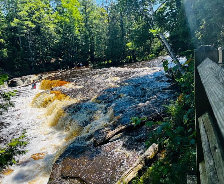
This is a highlight of the eastern Upper Peninsula and one of the top travel destinations in Michigan. The Tahquamenon Falls are two sets of falls on the Tahquamenon River: the Upper Falls, nearly 200 feet across and 50 feet high, is the second most voluminous waterfall east of the Mississippi after Niagara, and the Lower Falls are a series of cascades around an island four miles downstream.
The drive itself is M-123, which loops up from Newberry through the park to Paradise on Whitefish Bay, with the Upper Falls entrance at 41382 W. M-123. Tahquamenon Falls State Park is close to 50,000 acres of forest in Chippewa and Luce counties, most of it roadless, so whichever direction you come from you’ll be treated to an explosion of red, yellow, and orange. This is one of my favorite destinations in the fall. You’ll need a Recreation Passport on the car, the Upper Falls overlooks are reached by a paved 0.4-mile path, the park lends a track chair at no cost, and leashed dogs are welcome on most trails. Peak here is usually the first two weeks of October.

Northern Lake Michigan Shore: US-2 from Brevort to Naubinway
The northern shore of Lake Michigan is seriously underrated: in summer the beaches along US-2 are some of the best swimming in the state, and in fall the road is one long overlook. You pick it up by crossing the Mackinac Bridge and heading west out of St. Ignace, and the color runs the full 40 miles to Naubinway, with Lake Michigan on your left the entire way.
The stop that matters is the Cut River Bridge, about 25 miles west of St. Ignace between Brevort and Epoufette in Mackinac County. It’s a 641-foot steel cantilever bridge finished in 1947, and it carries US-2 147 feet above a gorge that fills with color in October. There’s a roadside park at each end, and a stairway of more than 230 steps drops to the river and a trail out to the Lake Michigan beach, about a 1.5-mile loop if you do the whole thing. It’s one of the prettiest scenic overlooks in Michigan, and the view from the bridge deck is the one you’ll photograph. Keep going west past Epoufette for the roadside overlooks that make this stretch some of the most stunning fall foliage in Michigan, and remember the shoreline peaks a week or so behind the inland forest.

Pictured Rocks National Lakeshore: H-58 from Grand Marais to Twelvemile Beach
One of two national lakeshores in Michigan, Pictured Rocks National Lakeshore runs 42 miles along Lake Superior in Alger County, and the paved county road H-58 runs the length of it. The sandstone cliffs are the famous part, but the eastern end out of Grand Marais is the fall color drive: dunes, beech and maple forest, and the lake showing through the trees.
Pick up H-58 in Grand Marais and head west past the Grand Sable Dunes and the Log Slide overlook to the Hurricane River day-use area, about 12 miles out. This is one of my favorite color drives in Michigan. From the Hurricane River lot, a flat 1.5-mile walk on the old Coast Guard road leads to the Au Sable Light Station, an 86-foot tower from 1874 and the only lighthouse in the park, with shipwreck timbers on the beach along the way. Ranger-led tours and tower climbs run in summer; by October you’ll have the grounds to yourself. Twelvemile Beach is three miles farther west. Pack hiking shoes, because you’ll find a hiking trail or two you can’t pass up, and the National Park Service’s Au Sable Light Station page has the walk and tour details.
If you go: the Holiday Inn Express is one of my favorite spots to stay when I visit the Pictured Rocks, because I always get a good night’s sleep. Whether it’s the mattresses, pillows, or both, it works. It’s also very clean and the waterfront views are quite pretty. There’s a good, free warm breakfast here, too.

Peter White Drive in Presque Isle Park, Marquette
Presque Isle Park is a 323-acre forested peninsula on Lake Superior at the north end of Marquette, and Peter White Drive is the two-mile loop road around it. It’s a free city park and one of the most popular destinations in Marquette, and here’s the best part: surrounded by forest and cliffs over the lake, it never feels crowded. Visit in the fall and you’ll be shocked by the sheer beauty of the place.
Marquette’s Black Rocks cliffs are here, and the mix of gleaming black rock, bright blue Lake Superior, and electric gold and red leaves is just amazing. Two things to plan around. The city closes the loop to cars for set walking hours each week in season, and closes it to vehicles for the winter as soon as snow arrives, usually early November, so a late-fall visit may mean walking the loop. And dogs aren’t allowed in the park at all, even leashed, under a city ordinance. Hours are posted on the City of Marquette’s Presque Isle Park page. Marquette’s color usually peaks the first or second week of October.

Upper Peninsula Fall Color Drives in the Western U.P.
Black River National Forest Scenic Byway: County Road 513 from Bessemer to Lake Superior
North of Bessemer in Gogebic County, at the far end of the western Upper Peninsula, County Road 513 follows the Black River 11 miles through the Ottawa National Forest to Lake Superior. It was named a National Forest Scenic Byway in 1992, and in late September it’s one of the most peacefully beautiful fall color drives in Michigan. Five major waterfalls sit just off the road: Great Conglomerate, Potawatomi, Gorge, Sandstone, and Rainbow, each a short hike from its own parking area, with Potawatomi reachable on a 600-foot trail to a viewing platform. In September you can watch salmon running upstream below Rainbow Falls.
Partway up the byway is Copper Peak, the largest ski-flying hill in North America, where the Adventure Ride takes you up an 800-foot chairlift and an 18-story elevator to an observation deck looking over 2,500 square miles of three states and Canada. It’s the best fall color view in the western U.P. and the one I’d build the day around. In 2026 the ride runs Sundays only, 9:30 a.m. to 4:30 p.m. Central Time, while the hill is rebuilt for international ski jumping; tickets are sold at the gate. The byway ends at Black River Harbor, the only harbor the Forest Service runs in the lower 48, with a suspension footbridge and a Lake Superior beach. From here you’re an hour southwest of the Porcupine Mountains and the Lake of the Clouds. The Forest Service’s Black River Scenic Byway listing has the falls map, and Copper Peak posts its Adventure Ride hours and prices.
If you go: continue on to Ontonagon and stay at Miller’s Cottages, one- and two-bedroom cottages and chalets in the woods a minute’s walk from Lake Superior.

Copper Harbor: Brockway Mountain Drive
Way up at the tip of the Keweenaw Peninsula in Copper Harbor, Brockway Mountain Drive is the most celebrated color drive in the Upper Peninsula. The nine-mile road leaves M-26 just west of town, climbs the ridge of the Keweenaw Fault to 1,320 feet above sea level, 720 feet above Lake Superior, and drops back to M-26 near Eagle Harbor. It’s the highest paved road between the Rockies and the Alleghenies, built by hand with Depression-era labor in 1933, and the pull-offs along the top give you a 360-degree view of Lake Superior, the inland lakes, and a canopy that turns red and gold in the last week of September.
Plan around the calendar. The road isn’t plowed, so it closes to cars for the winter, typically in late October, and it opened late in spring 2026 after storm damage. Keweenaw County is also the earliest-peaking color in Michigan, so the last days of September are the target, not Columbus Day weekend. Visit Keweenaw posts opening and closing notices, and the Daily Mining Gazette covered this year’s delayed opening. Leashed dogs are fine at the overlooks.

If you go: a lakefront condo at Lake Fanny Hooe Resort in Copper Harbor has a deck over the water, so you can take your own color tour from a chair.
The Michigan Traveler
U.P. color is a two-week window that moves 20 miles a day, and every year someone drives six hours to a bare hillside. From September on I send out where the color actually is each week, which road just closed, and which drive to do this weekend instead of next. Ride along.
Upper Peninsula Fall Color FAQs
When is peak fall color in the Upper Peninsula?
The western U.P. (Keweenaw, Porcupine Mountains, Bessemer) peaks in the last week of September into the first week of October. The eastern U.P. (Tahquamenon, Les Cheneaux, US-2) follows in the first two weeks of October. Anything directly on Lake Superior or Lake Michigan runs five to ten days behind the forest a few miles inland.
Can I do all seven drives in one trip?
Not at peak. The two western drives and the five eastern ones are 400 miles apart and peak about ten days apart. Do the west in late September and the east in mid-October, or pick one end and do it well.
Which U.P. fall drives are free?
All of the roads are free to drive. Tahquamenon Falls State Park needs a Recreation Passport on your vehicle, and the Copper Peak Adventure Ride is a paid attraction. Au Sable Light Station grounds are free to walk to.
Which drives allow dogs?
Leashed dogs are welcome at Tahquamenon Falls, on the Black River byway trails, at the Brockway overlooks, and on the Log Slide-to-Au Sable segment of the North Country Trail. Presque Isle Park in Marquette doesn’t allow dogs, even in a car window.
Looking for More Upper Peninsula Fall Color Drives?
If the Keweenaw sold you, my Copper Harbor guide has the rest of the peninsula, and the top Michigan fall spots list picks up where the bridge ends. Tell me which drive you take, and which week.
- About Jill
- Recent Michigan Travel Tips

Jill Halpin is a Michigan travel expert and founder of MyMichiganBeach.com. She has been sourced by The Washington Post and featured in The Detroit News and Detroit Free Press, and appears regularly on WDIV Detroit, FOX 2 Detroit, FOX 17 West Michigan, FOX 32 Chicago, WGN Chicago, and NewsNation — 60+ television appearances to date. She holds an MLIS from Wayne State University and is a Library of Congress Information Science Fellow. See all media features.